A Spinning Column of Water Rising From the Sea
A waterspout looks like something a special effects team invented for a disaster film. It is a rotating column of air and water mist that connects an active cloud above to the ocean surface below, forming a visible, twisting tube that can stretch hundreds of feet into the sky. Despite appearances, most waterspouts are not freak catastrophes. They are a fairly routine feature of warm coastal weather around the world, appearing regularly near tropical shorelines and island chains. That said, not all waterspouts are the same, and understanding the difference between the two main types explains a great deal about when one is merely spectacular and when it becomes genuinely dangerous.
One Italian Hotel Room, One Remarkable View
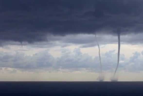
Freelance illustrator Nicola Ferrarese was staying at a hotel in San Bartolomeo al Mare, a small coastal town on the Italian Riviera, when he looked out toward the sea and found two waterspouts actively forming offshore. The sight was striking enough to capture on video. San Bartolomeo al Mare sits on the Ligurian coast, a stretch of Mediterranean shoreline known for warm summers and dramatic summer storms rolling in from the sea. The conditions that day were apparently just right. The footage Ferrarese recorded shows twin columns hanging from the cloud base and reaching toward the water below, both fully formed and clearly visible against the overcast sky. It is the kind of scene most people only encounter in nature documentaries.
Read more
Two Types, Very Different Risk Levels
Waterspouts fall into two distinct categories, and scientists treat them as fundamentally different phenomena despite their similar appearance. Tornadic waterspouts are, in the plainest terms, land tornadoes that happen to form over water. They develop inside severe thunderstorms and carry the same destructive energy as their onshore counterparts. Fair-weather waterspouts, by contrast, form under relatively calm conditions and pose little real danger under most circumstances. The two types develop through different physical processes, reach different intensities, and behave differently once they form. Lumping them together because they look alike is a bit like calling a bonfire and a candle flame the same thing because both produce light.
Why Tornadic Waterspouts Demand Respect
Tornadic waterspouts form when air inside a severe thunderstorm begins rising rapidly and rotating around a vertical axis. As that rotation tightens and the column stretches downward toward the water, it becomes a fully developed waterspout carrying the same physics as a land tornado. National Geographic describes them as the most powerful and destructive type of waterspout, and the surrounding conditions typically make them more hazardous still. They arrive paired with high seas, large hail, and frequent lightning, turning the area around them into a genuinely dangerous environment for any vessel caught nearby. Unlike their fair-weather cousins, tornadic waterspouts can travel significant distances, maintaining their strength for as long as the parent storm sustains them.
How a Fair-Weather Waterspout Actually Builds
Fair-weather waterspouts follow a different and somewhat counterintuitive path. Rather than descending from a violent storm system, they build upward from the sea surface toward the cloud base above. The process begins when a developing cumulus cloud creates a zone of rising warm air. Near the water, that rising motion can trigger a rotating updraft, and under the right conditions that rotation organizes itself into a visible funnel climbing from the sea toward the sky. The cloud responsible is typically slow-moving and relatively modest in size, not the towering cumulonimbus associated with severe storms. This bottom-up formation process is one of the clearest physical distinctions between the two types and explains why fair-weather waterspouts tend to be weaker and shorter-lived.
Twenty Minutes and Then They’re Gone
Fair-weather waterspouts have a surprisingly short lifespan. From formation to dissipation, the entire event typically runs around 20 minutes. Because they are tied to slow-moving cumulus clouds rather than large storm systems, they do not travel far from where they first appeared, and they rarely intensify beyond their initial state. Once the atmospheric conditions that created them shift even slightly, usually as the associated storm begins to fully develop, the waterspout loses its organizing energy and collapses back into the sea. The footage filmed in Italy almost certainly shows fair-weather waterspouts at work, which would explain why they appear relatively contained and do not seem to be embedded inside a larger, violent weather system.
Warm Air and Humidity Are the Essential Ingredients
Waterspouts of either type depend on a specific combination of atmospheric conditions. Warm air temperatures and high humidity are non-negotiable ingredients, because both are required to sustain the energy budget of a rotating atmospheric column. Without sufficient moisture in the air, the visible water mist that makes a waterspout visible and coherent simply cannot form at the required scale. This is why waterspouts are overwhelmingly concentrated in tropical and subtropical regions of the world, where sea surface temperatures stay high and the lower atmosphere is loaded with water vapor for much of the year. Temperate latitudes do see them occasionally, including along parts of the European Mediterranean coast, but the global hotspots are clustered in warmer climates.
Florida Keys Sees Around 400 Per Year
The Florida Keys hold a well-documented distinction as one of the most waterspout-prone places on Earth. National Geographic puts the figure at approximately 400 waterspouts per year in that region, a number that reflects the near-perfect atmospheric setup the Keys provide. Warm Gulf Stream waters keep sea surface temperatures elevated year-round, and the humid subtropical air above them creates the kind of unstable atmospheric column that waterspouts need to organize. The geometry of the Keys also plays a role, as the shallow shelf waters heat quickly and create sea breezes that collide and generate the updrafts waterspouts require. For residents and regular visitors, waterspouts offshore are simply a routine feature of summer afternoons, spectacular enough to photograph but rarely a cause for serious alarm.
Greek Islands and Australian Waters Are Also Hotspots
Beyond Florida, two other regions stand out as consistent waterspout territory. The Greek islands sit in the eastern Mediterranean, where warm sea temperatures and frequent late-summer convective storms create reliable waterspout conditions from late spring through autumn. The Aegean and Ionian seas in particular see enough waterspout activity that local fishermen and sailors factor them into seasonal weather awareness. Off the east coast of Australia, the combination of warm Coral Sea waters and the active storm patterns that roll in from the Pacific creates another prolific zone. The Whitsundays and the waters north toward Queensland see regular waterspout activity, particularly during the Australian summer, when the tropical air mass sits over warm coastal waters for months at a stretch.
What Separates a Waterspout From a Tornado on Land
The core physics of a tornadic waterspout and a land tornado are nearly identical, but the surface they interact with changes several aspects of the experience. Land tornadoes pick up debris, soil, and structural material as they move, which adds mass to the rotating column and darkens its appearance. Waterspouts pull in water and mist, which gives them a lighter, more translucent look while still maintaining the rotating structure underneath. A waterspout that crosses from open water onto land effectively becomes a tornado at that point, complete with the debris-lofting behavior. Mariners are advised to treat any tornadic waterspout with the same level of caution as a land tornado, giving it wide berth rather than attempting to observe it from close range.
Why the Footage Keeps Surprising People
Video and photographs of waterspouts consistently generate strong reactions from people seeing them for the first time, and the reason is straightforward: nothing in ordinary daily experience prepares the eye for the sight of a rotating atmospheric column visibly bridging the gap between ocean and cloud. The sense of scale is difficult to process. The column appears thin from a distance but can be hundreds of feet in diameter at its base, and the rotation, while visible in good footage, moves faster than it appears. Fair-weather waterspouts in particular look almost gentle from a safe distance, which is part of what makes them so photogenic. They are powerful enough to be visually dramatic but usually not violent enough to pose immediate danger to observers on shore, creating a rare situation where nature is putting on a genuine spectacle within relatively safe viewing range.